Thursday, December 8, 2011

The 2011 Tornado Season A devastating lesson


The 2011 Tornado Season 
A devastating lesson
By Mr Twister (Zach Roberts)


2011 was a tornado season for the record book. Monster storms plagued much of the Midwest and South Eastern United States with severe weather and killer tornadoes. An astounding number of lives changed forever as a result of this unprecedented past severe weather season. In the coming years, there will be a number of articles, books and documentaries released that will revisit different aspects of the 2011 tornado season.  I would like to submit my contribution.
As a storm chaser, I wait with unbridled anticipation for the spring severe weather season. My passion for understanding the power of nature in its purest form has always come with an understanding that with this power also brings death and destruction. I, along with all other storm chasers, watched in horror as these tornadoes claimed the lives of men, women and children in the spring of 2011. Unfortunately, this was the tornado season I feared was inevitable. The number of stories relating to the 2011 tornado season could fill multiple books, and each is unique. I will cover the tornado outbreak occurring the week of April 27th, and the Joplin tornado as these were the most devastating storms from the most devastating tornado season in at least 30 years.  I will then review some basic tornado information.
Throughout the week of April 25th-28th, 2011, an unparalleled tornado outbreak swept throughout the South Eastern United States, causing cataclysmic destruction. An unfortunate series of meteorological ingredients blended to create an explosive tornado environment. Instability resulting from a cold front plowing into warm humid air lingering over the South Eastern US aided by a powerful jet stream providing spin resulted in a super tornado outbreak not seen since 1974. This event would produce some 353 tornadoes that caused 346 deaths and left an immeasurable amount of damage to 
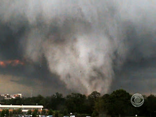
affected regions. Perhaps the most notable tornado from this outbreak occurred in Alabama on April 27th. This monster tornado was caught on film by multiple television stations as it marched across the city of Tuscaloosa, and later Birmingham. Many watched in awe as secondary or multiple vortices snaked from the ominous black core as it churned across the city.  This giant EF4 wedge tornado left a path of damage more than 80 miles long, and was measured to reach widths of more than one and a half miles wide.  Film evidence shows the monstrous storm tearing through factories and metropolitan areas alike, leaving 43 people dead and more than 1,000 injured.  Although the Tuscaloosa tornado was not the strongest tornado to strike that day, it has become the visual stamp of this fateful week. The 24-hour-period from 8:00 a.m. April 27 to 8:00 a.m. April 28 would be the fifth deadliest tornado day in United States history. States of Emergency were declared in Alabama, Arkansas, Kentucky, Mississippi, Missouri, Tennessee and Oklahoma.  The destructive weather and subsequent flooding forced President Obama to declare a federal state of emergency in Alabama.  The series of storms would leave entire cities and regions without power.  Largely affected were the customers of the Tennessee Valley Authority, which lost most of the power on their grid as destructive weather and winds left transmission towers damaged.


Less than a month after the super outbreak in the South Eastern United States, the epic tornado season would produce yet another tragedy that left many in shock. The city of Joplin, a small town in Missouri near the border of Oklahoma and Kansas would be struck by a EF 5 tornado on May 22nd 2011. Although severe weather events are a common occurrence in Joplin, the residents were not prepared for the destructive EF5 wedge tornado that ravaged the city from 5:34pm to 6:12pm on that fateful day. The tornado had a base estimated at one mile wide, blasting winds estimated at 200 to 250 miles per hour, and left a path of destruction that would total some $3 billion. Sadly, an estimated 161 lives were lost in the Joplin tornado alone.  The St. John’s Regional Medical Center in Joplin endured a direct hit from the tornado, and Dr Kevin Kikta was on duty that day. Below is an excerpt from Dr Kevin Kikta's personal blog recalling that day. A link to the full blog is listed below.  
"At 5:42 pm a security guard yelled to everyone, “Take cover! We are about to get hit by a tornado!”  I ran with a pregnant RN, Shilo Cook, while others scattered to various places, to the only place that I was familiar with in the hospital without windows, a small doctor’s office in the ED. Together, Shilo and I tremored and huddled under a desk.  We heard a loud horrifying sound like a large locomotive ripping through the hospital.  The whole hospital shook and vibrated as we heard glass shattering, light bulbs popping, walls collapsing, people screaming,  the ceiling caving in above us, and water pipes breaking, showering water down on everything.  We suffered this in complete darkness, unaware of anyone else’s status, worried, scared. We could feel a tight pressure in our heads as the tornado annihilated the hospital and the surrounding area.  The whole process took about 45 seconds, but seemed like eternity. The hospital had just taken a direct hit from a category EF5 tornado".


             The 2011 tornado season could be a once in a lifetime event. We may or may never see (in our lifetime) such a destructive set of circumstance come together as was witnessed in the spring of 2011. We do however know that each spring tornadoes will strike. Some will be weak only affecting rural areas of the Great Plains, but some will be strong, deadly and affect urban areas. Much of the public is fascinated by tornadoes, but the many do not understand these killer storms. What is a tornado?  Where does a tornado form? What can I do to protect myself?
        

A tornado is a violent, dangerous, rotating column of air that is in contact with both the surface of the earth and a cumulonimbus cloud or, in rare cases, the base of a cumulus cloud.

          Tornadoes have appeared everywhere on earth save Antarctica, are most common in North America and are especially common in the United States. Tornadoes in the U.S. are most likely to occur in a block of land in the middle of the country, from about North Dakota to mid-Texas. This area of land is often referred to as Tornado Alley. Texas gets the most tornadoes per year, followed by Kansas and Oklahoma. On average 1300 tornadoes are recorded in the U.S. every year and kill about 60 people.


Tornadoes can’t really be predicted and can only be minimally prepared for. Powerful ones routinely uproot even large trees, toss cars around, destroy buildings and leave behind so much debris that roads and railroads are impassable. Some tornadoes are weak and may be only a few feet across, while large tornadoes can span a mile or more in width and travel hundreds of miles on the ground. However, most tornadoes are about 500 feet wide, are in contact with the ground for about five miles and only last about ten minutes or less, though if a person’s in the path of one, that’s a very long time! Most tornadoes arrive late in the afternoon or the early evening. Generally, they move from west to east, but some have been known to switch direction, or even double back on themselves. Peak season in the U.S. is from April to July, but tornadoes have been recorded at all times of the year.

There are a few species of tornadoes. Multi-vortex tornadoes have more than one funnel that swirl around a common center. Waterspouts occur over water, and land spouts are associated with storms that aren't as strong and land spouts don’t last as long as classic tornadoes. For all its weakness, a land spout can still do considerable damage.


      It’s easy enough to see tornadoes coming, if it’s visible in the first place. Some tornadoes aren’t visible due to being wrapped in rain, or they come at night where they are difficult to see. Most people hear tornadoes only when they are dangerously close and describe the noise as being like a freight train rumbling by at close range. If a person sees a tornado approaching they should immediately seek shelter. If you are outdoors you should lie in the nearest ditch or piece of land that is lowest in elevation with your arms over your head. If you are indoors, you should take shelter in a basement or the lowest level of the structure. If there is no basement, you can take shelter in the most interior room available such as under stairs or in a bathroom. Some people believe that the doors and windows facing away from the storm should be opened to equalize air pressure, this is false. Taking precious time to open windows will likely get you killed. Many of these old wives tales are still believed to be true and have been perpetuated by the internet. If you are in a vehicle as a tornado approaches, never try to out run the storm. You should evacuate your car immediately and locate the nearest ditch to take shelter in. Never seek shelter under an over pass, as the tornado passes the overpass will create a wind tunnel and you could be sucked out. Mobile homes are not able to withstand even the weakest tornado and should also be evacuated as the tornado approaches. Every home and business should have an emergency plan in place in the event that a tornado warning is issued. In the event that the electricity has gone out, it is advised that each home and business should own a battery operated weather radio. This type of radio is inexpensive and can be purchased at any electronics store. Always take a tornado watch and a tornado warning seriously. A tornado watch means the environment exists for the development of tornadoes. A tornado warning means that a funnel or tornado is visible via radar or eye witness and is moving towards your location.


In hindsight, the tornado events of 2011 have brought tornado safety to a new light, but the average lead time on a tornado warning is a paltry 13 minutes. As technology and awareness grows it is believed that this warning lead time can be increased. We still do not fully understand tornadoes, and storm chasers, meteorologists and scientists are working feverishly to get a better idea of why these monsters can be weak or strong and leave one block unscathed while destroying the next. As fascinated as I am with tornadoes and weather, I do not enjoy the death and destruction that they bring. So please, stay up to date on severe weather by staying tuned to the National Weather Service, our website www.chasingthetornado.com , our Facebook page http://www.facebook.com/FollowMrTwister?
ref=ts, our Twitter feed @mrtwisterchaser and this blog.

Photos and graphics not taken or created by Mr Twister.
Sources: NOAA, TWC, NWS, Alabama NWS,Tuscaloosa News, FOX Channel 6, NCAR, Dr Kevin Kikta, CNN
Link to Dr Kevin Kikta's blog- http://www.mercy.net/joplin/stories-of-mercy/45-seconds

Wednesday, November 2, 2011

Nebraska June 20th, 2011 Outbreak


Wow...what an adventure this was.
I had been monitoring the potential for a tornado outbreak in South Central NE/Northern Kansas for a few days, and made the decision early on that I was going to chase this storm. All of the important numbers were pointing towards a major out break on June 20th. As I have done in the past, I decided I would ask Mrs Twister if she wanted to make a vacation out of it. In her sarcastic voice "Sure Mr Twister". So, on June 17th we gathered all of the necessary equipment for a vacation and a storm chase. Having to gather all of the required road trip items for a four and a eleven year is never easy. We managed to get everything done and headed out the door at 7am June 18th. 
The first stop on our adventure was Mt Rushmore. I had not been since I was a kid, and Mrs Twister and the kids had never been. We arrived to great weather, and a wonderful environment for viewing one of our countries amazing feats. If you have not been, or you have not been for awhile, some major improvements have been made to the area surrounding Mt Rushmore. The addition of a museum, a trail that allows you to walk to the base of the mountain and a walkway with every state's flag hung high. After a fun day, we headed into Rapid City for dinner, and some rest. I needed to look at the new outlook for the chase target. To my excitement the outlook had become even more favorable for tornadoes, and my target would be Grand Island Nebraska. My original target had been farther to the North and East, so I had some ground to cover. 
After a nights sleep, some swimming for the kids and few more local attractions, we were on the road to Sioux Falls South Dakota. We arrived in Sioux Falls late the evening of June 19th. I again reviewed the data for moisture, shear, front position, CAPE values and some other items, and was happy to see that my target was still Grand Island. 
As always, it was like Christmas Eve for a ten year old, and I could not sleep very well. I woke up bright and early on June 20th, kissed the family goodbye, and I was out the door. I tend to avoid bringing family members on chases that pose great danger. 
Heading south towards Omaha and Lincoln, I encountered major flooding. This particular area had been under flash flood warnings for the majority of the summer, and now I was seeing this first hand. The flooding caused some detours for my route, but I eventually made my way to Grand Island at 12pm CDT. 
I pulled into Grand Island, as I have many times, grabbed some lunch and reviewed the numbers again. To my surprise the SPC had issued a PDS "Particularly Dangerous Situation" for South Central Nebraska. This is the grand daddy of watch's, and typically will be issued when their is the potential for a significant tornado outbreak with the possibility for large and long track tornadoes. My feelings were mixed. This could be very dangerous, and I am a little nervous. This could be an epic outbreak, and I am excited. This could be deadly, and maybe I can save some lives. I called Mrs. Twister to give her the latest information, and I took my dog Bella out for a bathroom break. As I return to the car, warnings were starting to light up on a few storms in Northern Kansas. Shoot was I to far to the North East. 
I watched these initial storms in North Kansas, and they began to spin tornadoes. I reviewed the maps, and made the decision that I was to far East, and as the front crossed into Nebraska it would initiate storms near Kearney Nebraska. I collected my thoughts, and started heading West. The reports were arriving fast and furious, large tornado on the ground in Kansas. I was happy, and I figured I had snuffed out a near miss. Towers began to form along I-80, and I knew that it would not be much longer. 
I arrived in Kearney, and almost immediately storms initiated...went severe....and went tornado warned. I noticed that a group of chasers were even further West than I was, and they were reporting a tornado on the ground in Nebraska. I maintained my position, and followed my strategy of tracking the cells furthest to the South of initiation. 
Storms began to billow up directly over my head, and the structure of these cell's was incredible. These cells immediately began to drop pea to marble size hail.  Hail was bombing my Impalla, and knew I needed to get out of the hail core and move towards any developing wall clouds. As I viewed radar, I notice that just East of Kearney the current cell was forming a hook echo. I made my way to a county road that would allow access to the East and Southern portion of the storm. As I emerged from the hail core, the wall cloud nearly dropped on my hood. The clouds were dancing and spinning, and the color was an ominous green. This storm was moving North East, and it was moving fast. 
I made my way to a clearing where I had clear visual of the wall cloud, and almost on cue the storm begins to lower and a funnel emerges. My excitement is boiling over, and I grab my camcorder. As I turn back to the funnel, it reaches the ground and I have an official tornado. I call the siting into the local authorities and position myself on the dirt road to get the best. shot. A beautiful picturesque, white, elephant trunk tornado quickly develops. I capture the beast, as it arches from the base of the super cell, and lumbers for a few hundred yards. As quickly as it grew into a text book cone, it begins to evolve into a rope and dissipates before my eyes. 
Wow, that was a great start. I have a feeling that this cell is not done producing, so I start to head North in pursuit. I travel no more than half a mile, and directly in front of me is a serpent like rope tornado skimming across the dirt road. As it snakes back and forth, I grab my camcorder, and I am able to capture my 2nd tornado. Two tornadoes in a matter of ten minutes. Sadly to say, this would be the end of my tornado captures for the day. I would pursue the same storm for fifty miles, and it did produce some amazing photos, but no more tornadoes. 
What a day, I was as happy as a clam. Turns out I did miss two very nice tornadoes near Grand Island. Yes, my original position. Storm chasing is such an inexact science, and one miscalculation can cause your day to become a bust. Luckily, this event produced many tornadoes, and I was able to document two of them. 
Overjoyed with my chase day, I made my way back to the hotel in Sioux Falls. I had no choice but to follow the front as it marched North East towards Iowa and South Dakota. On my way back, I encountered major hail, lightning, wind, flooding, and a speeding ticket. Crap, another risk of storm chasing. 
PLEASE GO TO www.mrtwisterfanpage.com to see pictures, maps, video and NOAA full report on this outbreak. 

Mr Twister

Saturday, October 22, 2011

"The One That Started It All"

Tornado outbreak Denver/Thornton CO June 3rd 1981. 

On June 3rd of 1981 I was four years old, and I remember it like it was yesterday. My family and I were at my grandmothers house in Denver CO, and I was doing what ever a four year old does. It was a beautiful Colorado day. Warm and perfect for hanging out in my grandmothers backyard. My, how that would change. Around 2:15 PM we heard the tornado sirens sounding. This was not unusual, as Denver often had tornado warnings. We quickly moved to the front room to get a better view of the situation. My aunt observed an unusual amount of trash was hovering in the air. My mom makes a very astute observation by saying "when is there a normal amount of trash in the air"? The trash was dancing in a circular pattern in the sky above Yates St. It was as if a large pot of stew was being stirred with a giant ladle. I had never seen anything like this. I was in awe. The debris continued to grow larger and more prevalent. The sky grew a off shade of emerald green. At the tender age of four, even I knew this was not a normal storm. At this point we made the decision to move everyone to the cellar. I was scared.....but I was oddly intrigued. No, this was not Mr Twister's first tornado siting. My mother grabbed me like a football, and ran to the cellar like a fullback. This was no easy task, as my grandmother's cellar was very small and there was seven of us. It was dark, it was loud and it was over quick. We emerged shaken, but we were ok. I did not see a tornado...I don't even think I saw a nasty cloud, but this started my fascination with weather. How could such a wonderful summer day turn so dangerous, so quick? How could a blue sky turn green? As we surveyed the damage, we realized the tornado missed Yates by a block. The damage was substantial, and several buildings a  tenth of a mile to the West were destroyed. This period was very volatile for Denver weather, as the following year, the Christmas blizzard of 1982 would bury Denver. From that point on, I decided I wanted to follow weather. I would wait on my roof for storms to form near the foothills of Denver. I would create my own weather maps, and I would track cold fronts as they marched across the country. I would cut paper clippings of any event related to weather..creating my own weather log. To this day, I have an insatiable passion for weather, and now I have all this neat technology to share my adventures with you. Attached is a brilliant study of that infamous day in Denver weather. Mr Twister

Tuesday, October 18, 2011

Mr Twister starts a blog.

Twister nation,


Mr Twister is growing rapidly, and we are chugging along to keep up with the growth. This blog will be aimed at trying to contain all of our deep thinking in one location. Up until now, we have only utilized our Facebook page http://www.facebook.com/pages/Mr-Twister/233957776622970. This will still be a great spot for quick conversations, quick questions, fan interaction and a place for us to post pieces of our chase log. The main purpose of the Mr Twister blog will be to serve as a chase log. You will be able to find a detailed summary of all of our severe weather adventures. In addition, we will post chase map's, radar shots, meso-scale discussion, full picture albums, full video, and any other relevant information to that chase. We will also be posting detailed information regarding our "Join a Chase" program. We are very excited to share what, up until  this point, has been just me an my daughter on the open road. So, even though we are not in chase season, please keep an eye out for new blog posts....Mr Twister loves anything related to weather. 


Chase with passion!


Mr Twister