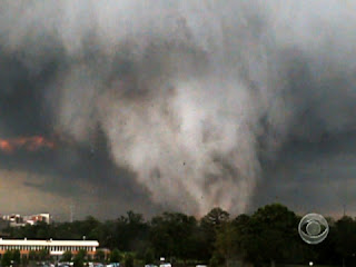
The term “worst case scenario” can mean a number of things in the severe weather world. Some scenarios that come to mind are extremely violent tornadoes, tornadoes at night, a tornado that directly hits a town. The Greensburg tornado was all three.
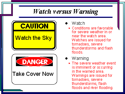
May 4 began in much the same way as many other spring days in the Great Plains. Cool, dry air from the north clashed with warm, moist air from the Gulf of Mexico, creating the sort of unstable atmosphere that is so common to "Tornado Alley." An intense low pressure system moved in and stalled over the area during the morning hours, providing all the ingredients that meteorologists and storm chasers expect for severe weather. With an extremely volatile mix of conditions in place, the National Weather Service began to issue watches in anticipation of developing storm activity.
By late afternoon and early evening, storms began to blow up across parts of Oklahoma, Texas and Kansas. Although the storms began with only moderate and disorganized activity, they developed quickly into well-organized, explosive storms. As the day wore on, the National Weather Service and Storm Prediction Center began to issue more urgent updates to alert the public to the growing danger. Several storm chasers began to close in on the southern portion of Kansas, where conditions appeared most favorable for twister development.
As evening approached, several thunderstorms began to take on the characteristics of a supercell thunderstorm. Supercells, which are intense, broadly rotating thunderstorms, are the most violent storms on Earth. They can persist for many hours, travel hundreds of miles, and spawn large numbers of tornadoes. On the evening of May 4, atmospheric conditions made it possible for a number of these supercells to sustain themselves for long distances, spawning twisters in cycles across their path.
After prompting several warnings across the area, storm chasers and weather spotters reported that a particularly violent supercell had spawned a funnel just southwest of Greensburg at 9:20 p.m. By 9:38 p.m., the storm had grown to a half-mile wide wedge as it approached the town, with several satellite vortices observed rotating around the main vortex. At 9:41 p.m., the National Weather Service station in Dodge City, Kan. issued an emergency statement for the town of Greensburg, indicating the extreme peril of the situation.
Shortly after the emergency statement was issued, the storm entered the town near its peak strength. The twister stayed on the ground for a total of 22 miles, passing entirely through Greensburg and leaving 95 percent of the city destroyed, with the remaining five percent significantly damaged. Damage surveys done after the storm found areas in which significant damage extended well in excess of a mile in width. Maximum wind speeds were estimated at 205 miles per hour, though the extent and degree of damage don't rule out a significantly higher wind speed.
The Greensburg storm was unique for several reasons. In addition to its ferocious intensity, the structure of the storm as recorded by storm chasers and weather radar was exceedingly uncommon. The main twister was accompanied by several satellite vortices during several points in its lifespan, adding to the resulting damage. The supercell itself was also rotating at tornadic velocities, which is a virtually unprecedented occurrence. The storm also remained visible for a large portion of its life, despite occurring at night, because of its frequent and intense lightning activity.
The Greensburg storm was the first to be rated an EF5, using the Enhanced Fujita scale that was introduced in February 2007. The Enhanced Fujita scale, or EF scale, was introduced as a more effective and accurate way to measure the destructive power and estimated wind speed of tornadoes. When damage survey teams assessed the damage left in Greensburg, they found a total of 961 homes and 110 business completely destroyed, with many wiped cleanly off their foundations. Despite the scale and severity of the damage, however, the number of deaths and injuries was relatively low. This was attributed in large part to the coordinated actions of storm chasing teams and National Weather Service personnel, which allowed warnings to be issued well in advance of the storm.
The frequent lightning, combined with the relatively slow forward speed of the storm, allowed storm chasers to report and document the storm more effectively than many other nighttime tornadoes. Storm chasers are an important part of the early warning system for tornadoes, because they are able to accurately confirm whether a twister is taking place, where it is located, and how large it is. During the Greensburg event, the high number of storm chasers in the area allowed weather personnel and authorities to pinpoint the areas in the path of the storm, leading to better warning time and more accurate alerts. Additionally, many chasers were among the first people on the scene after the storm had passed, assisting with search and rescue operations.
After passing through Greensburg, the storm followed a looping path that nearly caused it to strike the town a second time. The storm system continued on, spawning another massive twister shortly after that damaged the community of Trousdale. In all, the Greensburg supercell alone was responsible for as many as 22 tornadoes, including at least 12 twisters confirmed by the National Weather Service. During the three-day outbreak, a total of 123 tornadoes were confirmed across several states.
Although Greensburg was almost entirely destroyed, the storm helped to reinforce the important role that storm chasers play in the tracking and warning process of severe weather. By having well-trained, experienced people in the field, meteorologists and weather services are better able to track the exact location and characteristics of tornadic events, relaying that information to the public faster and more accurately than ever before.
Greensburg has moved on from the tragedy that occurred on May 4th 2007. From the shattered remains emerged a city that was rebuilt based on an environmentally friendly plan. Much of the city is brand new, and the residents hope to see the continued rebirth evolve for decades to come. One thing is for certain; even a mild thunderstorm will be taken seriously by anyone who saw the power that nature exerted on this small town in Kansas.


