

When some people think of storm chasers, they may think of the movie "Twister." While this movie did show what it is like to chase storms and try to figure out what causes tornadoes, like all Hollywood movies, it doesn't necessarily show you exactly what happens. In real life, those who chase storms usually do so in a less conspicuous manner. They typically work in areas where tornadoes are frequent so they have a greater chance of finding and studying the powerful storms.
What is a Storm Chaser? In general terms, a storm chaser is a scientist who tracks storms out in the field to study their behavior, particularly when tornados form. One of the main reasons people chase storms is to help determine how and why tornados form so they can develop better early warning systems. Some people refer to a person who chases storms as a tornado chaser because the main goal is to watch a tornado develop and collect information about the storm prior to, during and after the development of the tornado. For some people, storm chasing is more of a hobby, while others chase storms as their job. Those who chase storms as a hobby often want to witness a storm, not necessarily a tornado. Tornado chasers aren't the only type of chasers, though. Some people chase hurricanes as well, though this field is much smaller.
What Do Chasers Do? Someone who chases storms actually spends very little time actually observing storms and the tornados they create. In fact, a majority of a chaser's time is often spent driving around in search of active thunderstorms that are severe enough to warrant chasing. A chaser must closely monitor weather reports to get a good idea of where a storm is likely to hit to help find it. However, meteorology is not an exact science and weather men aren't always right. Therefore, a chaser must be prepared to drive around the area to find the storm at the right moment. In storm watching, timing is everything. A chaser can increase his chances of success by studying meteorology himself to understand storms and their behavior. Once a chaser finds a storm, he will often video tape or photograph the storm and potentially take readings with other types of equipment to study the severe weather and learn from it.
What Equipment Do They Use? Many people who chase storms use GPS units to help them find their destinations more easily. Gone are the days when chasers had to rely on maps to help them find the potential route for the storm. With a GPS, a chaser can quickly change his route to follow a storm without risking getting lost or making a wrong turn. Likewise, many chasers also use mobile Internet to monitor the weather forecast and collect other information about the storm while on the go. In 2004, a satellite-based positioning system was created to reduce the number of dead spots many chasers experienced when using cell services. Storm software, called GRLevel3, was also developed to give chasers access to raw radar footage to help track dangerous storms and watch for tornado signals. If chasers work in a group that travels in a caravan, cell phones or radio devices are used to maintain communciation between the different vehicles. Digital SLR cameras have become a staple for chasers to help them take high-quality digital images. The different settings can help a chaser get better pictures than ever before. Those who chase storms to study the elements often also use weather stations installed on top of the vehicle to record the conditions during a storm.
What Do They Look For? When some people think of a chaser, they automatically think that a person is a tornado chaser in particular. However, this isn't always the case. While the most common type of chaser does look for tornados, not all of them do. In general, a chaser is someone who is interested in severe weather and seeks it out to learn from it and watch it. Therefore, some chasers will follow any type of storm just to watch it. Others prefer to chase hurricanes instead of regular thunderstorms. Regardless of the preferred type of storm, each chaser watches for the same types of things. A storm chaser will monitor the weather forecast to determine when a severe storm will be in the area, and if one is not in the immediate area, where they can find one. When they go out to the site of the storm, they will look for a wall cloud or other signs of a potential tornado, such as rotation in the clouds or unusual cloud shapes. As they follow the storm, they will keep an eye on it for any changes that can indicate that the storm is becoming more severe. If the chasers are out in search of storms without any real knowledge of where the storm will be, they can look for signs of an impending storm. One of the things chasers look for is large white clouds with high tops. These clouds often develop into storms that can be severe. As they monitor weather reports, radar images and other weather information, they will look for certain things that can indicate the possibility of a severe storm. Watches and warnings are often issued in areas that show a strong potential of developing severe storms. When these are issued, chasers should head for the area as soon as possible to avoid missing the action. Other changes they look for include sudden drops or increases in temperature, cold fronts, changes in dewpoint and wind direction changes. All of these changes can indicate the presence of a strong storm, which can easily spawn tornadoes.
Famous Storm Chasers
While many people who chase storms are somewhat average people who simply have a fascination with severe storms, some people have become famous in the field. Those who have become famous have made great strides in determining how storms work and which conditions often lead to the formation of tornados, helping meteorologists more accurately predict the appearance of these dangerous storms.
Roger Hill. Hill is a native of Colorado and has witnessed more than 416 tornados as of 2009. His chases have been featured on television networks, such as National Geographic, the Weather Channel, Travel Channel and more. He has witnessed tornados all over the country, some that have caused a lot of damage.
Chuck Doswell. Doswell is well-versed in meteorology, making him a great chaser. He has a solid understanding of the types of storms that create tornados and how to safely follow them. He is member of several meteorological societies and has chaired many weather committees. His research helped develop the modern views of the supercell storm, those that are most likely to spawn tornados. Doswell has chased storms, both on a professional and a recreational basis. Even though he is retired, he still chases storms.
Reed Timmer. Timmer is one of the stars of the popular television show, "Storm Chasers." He has chased more than 250 tornados during his career, as well as more than a dozen hurricanes, giving him a wide array of experience in chasing storms. He has been interested in severe weather since he was young, which led him to go to college for meteorology, earning a PhD in the field. His show airs on the Discovery Channel and shoots footage year-round.
Eddy Weiss. Not only has Weiss made a name for himself in chasing storms, he directs an organization called Chasing4Life that helps people create disaster preparedness plans so everyone can feel safe when a storm threatens. In addition to his work in the storm field, he has also worked in crisis counseling and rescue work. Weiss uses all of his background together to help the average person prepare for severe weather.
The art of chasing storms can be dangerous if not done properly. While some people who are interested in severe weather may be tempted to just hop in the car and follow any storms in the area in hopes of locating a tornado, training and the proper equipment can be crucial for safety. Therefore, it is important to learn about the way storms operate and how to read severe weather, especially tornados, in order to stay safe. Until a person learns all of this crucial information about severe weather, storm chasing can be far too dangerous. Leaving it up to the professionals and watching from afar is the safest bet.
Subscribe To Mr Twister

 Posts
All Comments
Posts
All Comments
Showing posts with label tornado. Show all posts
Showing posts with label tornado. Show all posts
Sunday, January 1, 2012

Historic Tornado Series #1
Mr Twister
Historic Tornado Series
Part 1 of 10
The Bridge Creek-Moore
Oklahoma Tornado May 3rd, 1999

May 3rd 1999…mention this date to any resident of Oklahoma and you are sure to get a look of sorrow and fear. Tornadoes in Oklahoma in the spring are not an unusual thing. Natives of Oklahoma have become accustomed to the annual ritual of tornado sirens, and most understand that they live in the heart of tornado alley. The Bridge Creek-Moore Oklahoma tornado was not a typical tornado. This tornado was a monster of epic proportions. This beast packing winds of 300+ miles an hour caused destruction and death no one will ever forget.
Tornadoes can appear suddenly or be tracked as funnels by a storm chaser for miles before they touch down or dissipate. The EF scale (Enhanced Fujita Scale) for judging the intensity of the storm ranges from 0 to 5 with wind speeds of 110 miles per hour up to more than 300mph. An EF 0 will damage trees, small structures (sheds, playground equipment), and take shingles off the roof. An EF5 is capable of leveling buildings to the foundation and damaging large skyscrapers. The Bridge Creek-Moore Oklahoma tornado of May 3, 1999 was an EF 5.

The deadly tornado started its path near the community of Amber, Oklahoma and headed northeast, parallel to Interstate 44, just after another tornado had passed over the airport in Chickasha. First reported by storm chasing teams as having touched down in Grady County at 6:23 p.m., the tornado intensified almost immediately from an EF 4 to an EF 5 system. The tornado then crossed the Canadian River, passing into far southern Oklahoma City. As it passed over Bridge Creek, around 6:54 pm the D.O.W. (Doppler On Wheels) headed by storm chaser Josh Wurman detected winds of 301 mph inside the tornado at a height of 32m. These winds, however, occurred above the ground, and winds at the surface may not have been quite this intense. It wavered between EF 2 and EF 5 as it entered Cleveland County, but it hit its highest speed again as it ran through and destroyed the city of Moore. The cell dissipated at 7:49 pm, outside of Midwest City, after crossing Oklahoma County and battering the southern part of Oklahoma City.
The death toll from this monster tornado would likely have been higher if people had not had advance warning. Three local television stations in Oklahoma City: KFOR-TV (channel 4), KOCO-TV (channel 5) and KWTV (channel 9) provided life saving coverage of the Oklahoma tornado outbreak. Tornado warnings were issued well in advance of the tornado's arrival. The three stations' chief meteorologists Mike Morgan, Rick Mitchell and Gary England received commendations from then-governor Frank Keating for their coverage of the outbreak.

This tornado covered a 38 mile area in around an hour and twenty-five minutes. It destroyed several towns on the outskirts of Oklahoma City killing 38 people, injuring close to 600 people, doing a billion dollars worth of damage, and destroying or damaging over 8000 homes. A “tornado emergency” was issued for the Bridge Creek/Moore tornado, marking the first time this level of warning had ever been used. A “tornado emergency” is used when a violent tornado is about to impact a densely-populated area.
As disastrous as the Bridge Creek/Moore tornado was, it was only part of a much larger system that spawned over 140 tornadoes. These tornadoes were spread over a five state area and covered a good chunk of tornado alley. Stroud Oklahoma was hit by an F-3 tornado that destroyed the Tanger Outlet Mall, the local hospital and the Sigma Trucking terminal. While there were no fatalities in Stroud, the economic impact of the tornado was devastating. Mulhall Oklahoma was also hit by an F-4 tornado toppling the city's water tower and destroying most of the town. The Mulhall tornado was a wedge tornado, at times exceeding a width of one mile. Some storm chasers believe it may have been as violent, or more violent than the F-5 Moore/Bridge Creek tornado. ABC affiliate KTUL-TV in Tulsa located on Lookout Mountain was nearly hit by one of the last tornadoes of the outbreak. The outbreak claimed the lives of 6 people in Haysville and Wichita Kansas, 1 person in Texas and 4 people in Tennessee.

May 3rd was filled with death and destruction, but one reported miracle took place at Westmoore High School, outside of Eastlake Estates. There was a ceremony going on when the Bridge Creek/Moore tornado hit, but the students had enough time to find shelter in the building. Incredibly, while the structure itself was severely damaged and cars were destroyed, not a single person in the building was even injured.Unfortunately, some individuals tried to take refuge from the tornadoes under highway overpass and this decision ended up costing 3 people their lives. The Bridge Creek-Moore Oklahoma tornado hit 2 overpasses along I-44, while another struck an overpass north of Oklahoma City. It is a common misconception is that it that it is safe to hide under an overpass during a tornado, but this is not true. Never take refuge under an overpass. The safer alternative is to lie in the lowest piece of land available such as a ditch.

On May 4th, eleven counties were declared disasters. The Red Cross housed 1600 people in ten shelters that were opened overnight. FEMA sent several post-disaster teams, the US Dept. of Defense sent the 249th Engineering Battalion, and the Corps of Engineers were placed on standby. By the 6th, there were phone banks and donation centers functioning, and the Dept. of Health and Human Services had medical teams in attendance. Feeding stations were set up. Search and rescue continued through the 7th trying to find the thirteen who were still missing. By the 9th FEMA had approved about $180,000 for housing assistance. On May 12th seven teams were sent to aid in debris removal and people began to search for any belongings that survived the dreadful Bridge Creek-Moore Oklahoma Tornado of May 3, 1999. An outreach program was set up to help the victims deal with the stress of the trauma. People who were rebuilding were encouraged to add storm shelters on their property.

Thursday, December 8, 2011
The 2011 Tornado Season A devastating lesson
The
2011 Tornado Season
A devastating lesson
By
Mr Twister (Zach Roberts)
2011 was a tornado season for the
record book. Monster storms plagued much of the Midwest and South Eastern United
States with severe weather and killer tornadoes. An astounding number of lives
changed forever as a result of this unprecedented past severe weather season.
In the coming years, there will be a number of articles, books and
documentaries released that will revisit different aspects of the 2011 tornado
season. I would like to submit my
contribution.
As a storm chaser, I wait with
unbridled anticipation for the spring severe weather season. My passion for
understanding the power of nature in its purest form has always come with an understanding
that with this power also brings death and destruction. I, along with all other
storm chasers, watched in horror as these tornadoes claimed the lives of men,
women and children in the spring of 2011. Unfortunately, this was the tornado
season I feared was inevitable. The number of stories relating to the 2011
tornado season could fill multiple books, and each is unique. I will cover the tornado
outbreak occurring the week of April 27th, and the Joplin tornado as
these were the most devastating storms from the most devastating tornado season
in at least 30 years. I will then review
some basic tornado information.
Throughout the week of April 25th-28th,
2011, an unparalleled tornado outbreak swept throughout the South Eastern
United States, causing cataclysmic destruction. An unfortunate series of meteorological
ingredients blended to create an explosive tornado environment. Instability
resulting from a cold front plowing into warm humid air lingering over the
South Eastern US aided by a powerful jet stream providing spin resulted in a
super tornado outbreak not seen since 1974. This event would produce some 353
tornadoes that caused 346 deaths and left an immeasurable amount of damage to
affected regions. Perhaps the most notable tornado from this outbreak occurred in
Alabama on April 27th. This monster tornado was caught on film by multiple
television stations as it marched across the city of Tuscaloosa, and later
Birmingham. Many watched in awe as secondary or multiple vortices snaked from the
ominous black core as it churned across the city. This giant EF4 wedge tornado left a path of
damage more than 80 miles long, and was measured to reach widths of more than
one and a half miles wide. Film evidence
shows the monstrous storm tearing through factories and metropolitan areas
alike, leaving 43 people dead and more than 1,000 injured. Although the Tuscaloosa tornado was not the
strongest tornado to strike that day, it has become the visual stamp of this
fateful week. The 24-hour-period from 8:00 a.m. April 27 to 8:00 a.m. April 28 would be the fifth deadliest tornado day in United States history. States of
Emergency were declared in Alabama, Arkansas, Kentucky, Mississippi, Missouri,
Tennessee and Oklahoma. The destructive
weather and subsequent flooding forced President Obama to declare a federal
state of emergency in Alabama. The
series of storms would leave entire cities and regions without power. Largely affected were the customers of the
Tennessee Valley Authority, which lost most of the power on their grid as
destructive weather and winds left transmission towers damaged.


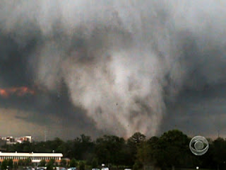


Less than a month after the super outbreak in the South Eastern United States, the epic tornado season would produce yet another tragedy that left many in shock. The city of Joplin, a small town in Missouri near the border of Oklahoma and Kansas would be struck by a EF 5 tornado on May 22nd 2011. Although severe weather events are a common occurrence in Joplin, the residents were not prepared for the destructive EF5 wedge tornado that ravaged the city from 5:34pm to 6:12pm on that fateful day. The tornado had a base estimated at one mile wide, blasting winds estimated at 200 to 250 miles per hour, and left a path of destruction that would total some $3 billion. Sadly, an estimated 161 lives were lost in the Joplin tornado alone. The St. John’s Regional Medical Center in Joplin endured a direct hit from the tornado, and Dr Kevin Kikta was on duty that day. Below is an excerpt from Dr Kevin Kikta's personal blog recalling that day. A link to the full blog is listed below.
"At 5:42 pm a security guard yelled to everyone, “Take
cover! We are about to get hit by a tornado!”
I ran with a pregnant RN, Shilo Cook, while others scattered to various
places, to the only place that I was familiar with in the hospital without
windows, a small doctor’s office in the ED. Together, Shilo and I tremored and
huddled under a desk. We heard a loud
horrifying sound like a large locomotive ripping through the hospital. The whole hospital shook and vibrated as we
heard glass shattering, light bulbs popping, walls collapsing, people
screaming, the ceiling caving in above
us, and water pipes breaking, showering water down on everything. We suffered this in complete darkness,
unaware of anyone else’s status, worried, scared. We could feel a tight
pressure in our heads as the tornado annihilated the hospital and the
surrounding area. The whole process took
about 45 seconds, but seemed like eternity. The hospital had just taken a
direct hit from a category EF5 tornado".


The 2011
tornado season could be a once in a lifetime event. We may or may never see (in
our lifetime) such a destructive set of circumstance come together as was
witnessed in the spring of 2011. We do however know that each spring tornadoes
will strike. Some will be weak only affecting rural areas of the Great Plains,
but some will be strong, deadly and affect urban areas. Much of the public is fascinated
by tornadoes, but the many do not understand these killer storms. What is a
tornado? Where does a tornado form? What
can I do to protect myself?
A tornado is a violent, dangerous, rotating column of air that is in contact with both the surface of the earth and a cumulonimbus cloud or, in rare cases, the base of a cumulus cloud.
Tornadoes have appeared everywhere on earth save Antarctica, are most common in North America and are especially common in the United States. Tornadoes in the U.S. are most likely to occur in a block of land in the middle of the country, from about North Dakota to mid-Texas. This area of land is often referred to as Tornado Alley. Texas gets the most tornadoes per year, followed by Kansas and Oklahoma. On average 1300 tornadoes are recorded in the U.S. every year and kill about 60 people.


Tornadoes can’t really be predicted and can only be minimally prepared for. Powerful ones routinely uproot even large trees, toss cars around, destroy buildings and leave behind so much debris that roads and railroads are impassable. Some tornadoes are weak and may be only a few feet across, while large tornadoes can span a mile or more in width and travel hundreds of miles on the ground. However, most tornadoes are about 500 feet wide, are in contact with the ground for about five miles and only last about ten minutes or less, though if a person’s in the path of one, that’s a very long time! Most tornadoes arrive late in the afternoon or the early evening. Generally, they move from west to east, but some have been known to switch direction, or even double back on themselves. Peak season in the U.S. is from April to July, but tornadoes have been recorded at all times of the year.
There are a few species of tornadoes. Multi-vortex tornadoes have more than one funnel that swirl around a common center. Waterspouts occur over water, and land spouts are associated with storms that aren't as strong and land spouts don’t last as long as classic tornadoes. For all its weakness, a land spout can still do considerable damage.


In hindsight, the tornado events of 2011 have brought tornado safety to a new light, but the average lead time on a tornado warning is a paltry 13 minutes. As technology and awareness grows it is believed that this warning lead time can be increased. We still do not fully understand tornadoes, and storm chasers, meteorologists and scientists are working feverishly to get a better idea of why these monsters can be weak or strong and leave one block unscathed while destroying the next. As fascinated as I am with tornadoes and weather, I do not enjoy the death and destruction that they bring. So please, stay up to date on severe weather by staying tuned to the National Weather Service, our website www.chasingthetornado.com , our Facebook page http://www.facebook.com/FollowMrTwister?
ref=ts, our Twitter feed @mrtwisterchaser and this blog.
Photos and graphics not taken or created by Mr Twister.
Sources: NOAA, TWC, NWS, Alabama NWS,Tuscaloosa News, FOX Channel 6, NCAR, Dr Kevin Kikta, CNN
Link to Dr Kevin Kikta's blog- http://www.mercy.net/joplin/stories-of-mercy/45-seconds
Wednesday, November 2, 2011
Subscribe to:
Posts (Atom)